Investigating a collapsed tunnel after a landslide in the Swiss Alps
Investigating a Collapsed Tunnel After a Landslide in the Swiss Alps
A road tunnel in the Swiss Alps was struck by a landslide, cutting off access to a village and disrupting a popular ski resort. The Elios 3 drone was deployed to assess the damage and help plan a safe recovery operation.
Key Benefits at a Glance
|
Safety The unstable conditions made it too dangerous to enter the tunnel, so local authorities used the Elios 3 for remote inspection and situational awareness. |
Efficiency The Elios 3 quickly collected both visual and LiDAR data, enabling swift analysis and planning of the response. |
|
Analysis The LiDAR point cloud provided detailed 3D visuals of the tunnel’s interior and the path of the landslide, aiding in understanding the cause of the collapse. |
Speed Thanks to the fast deployment, repair work started quickly, and the tunnel was reopened in June, reducing disruption during the busy summer season. |
Landslides are common worldwide, often triggered by natural factors like weather patterns or human activities such as deforestation and construction. In Switzerland, early spring is particularly prone to landslides due to melting snow and unstable ground conditions.
A Landslide in the Swiss Alps
On the night of February 3rd, 2024, several landslides hit the Riddes valley in Switzerland. One tunnel between Riddes and La Tzoumaz partially collapsed, isolating villages and disrupting access to a major ski area. Every day the tunnel remained closed added to the challenges faced by locals and visitors alike.
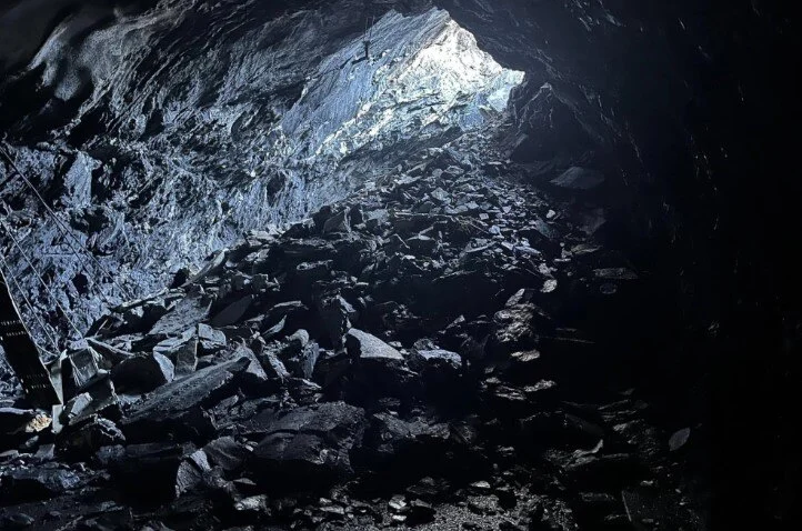 The interior of the tunnel was covered in debris. Image credit: Canton ValaisÂ
Accessing the tunnel was extremely dangerous, making it impossible for investigators to enter directly. However, quick action was essential to understand the situation and begin repairs.
In the heart of the Alps, local authorities turned to innovative technology to gather critical information about the disaster.
Planning the Investigation with Drones
The landslide occurred in the canton of Valais, and the local authorities needed to determine its cause and the extent of the tunnel damage. A full investigation would help improve future landslide predictions and mitigation strategies.
Due to the site's instability, entering the tunnel was not an option. So, the Valais authorities used the Elios 3 drone equipped with a Surveying Payload to capture images, videos, and LiDAR scans of the tunnel. This data helped plan the repair process and contributed to research on similar disasters.
This project was led by the Department de la Mobilité du Territoire et de l’Environnement, part of the Valais state authorities, with no external involvement.
Flying a Drone Inside a Collapsed Tunnel
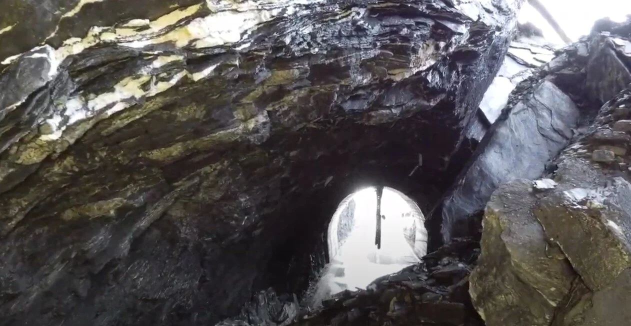
The tunnel, built decades ago, had a small window that allowed natural light and air into the structure. While this may have been a design oversight, it likely contributed to the tunnel’s structural weakness over time.
Within 24 hours of the incident, a drone pilot from the Valais authorities began planning the mission. The focus was on the area around the window, where the most significant damage occurred. Multiple flights were conducted using the Elios 3 to collect detailed data.
The visual feed from the Elios 3 showed how the landslide caused the tunnel’s roof to collapse
The first flights aimed to map the layout of the debris and assess the damage. LiDAR surveys were the main data source for planning clearance operations. Subsequent flights focused on the window and its potential role in weakening the tunnel structure.
Findings from Drone Surveys
The Elios 3 revealed that the tunnel had been slowly deteriorating for years. The open window allowed cold air to circulate, accelerating freeze-thaw weathering inside the tunnel. Over time, this weakened the structure and created vulnerabilities.
Additionally, the use of explosives during the tunnel’s original excavation may have caused decompression in the surrounding rock, further compromising the walls. These factors, combined with ongoing weathering and vibrations, eventually led to the collapse.
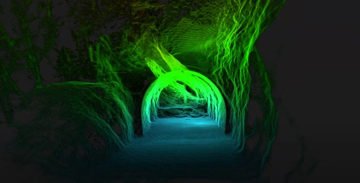
LiDAR scans clearly show the layout of the collapsed section and where the rocks entered
By 2023, signs of instability were already visible, including minor rockfalls near the window. These events gradually weakened the tunnel’s structural integrity, leading to the final collapse.
The Role of Drones in Emergency Response
Without the Elios 3, investigating the tunnel would have been extremely challenging. Sending personnel inside was too risky, and securing the area before any data collection would have delayed the response significantly. Drones allowed for immediate access and rapid decision-making.
A fly-through of the LiDAR scan shows the full extent of the damage
The use of the Elios 3 was crucial in this case. It enabled investigators to inspect the tunnel just one day after the incident, saving valuable time compared to traditional methods that could take days or even months. This approach not only improved efficiency but also ensured the safety of all involved.
By leveraging advanced technology, the Valais authorities were able to quickly gather vital data and begin repairs. The findings will be used to guide future infrastructure projects and better prepare for similar geological events, especially as climate change increases the risk of such disasters.
Stainless Steel Coil,Stainless Steel Coils,ss Coil, ss Coils,AISI Stainless Steel
Shandong Rizhaoxin Metal Products Co., Ltd. , https://www.cysteelcoil.com